
Mercedes-Benz GLC 2016-2026 Owners Manual / MBUX multimedia system / Navigation / Using map functions
Mercedes-Benz GLC : Navigation / Using map functions
Multimedia system:


 Navigation
Setting the map scale
 To zoom in: tap twice
quickly with one finger
on the media display.
To zoom in: tap twice
quickly with one finger
on the media display.
 To zoom out: tap with
two fingers on the
media display.
To zoom out: tap with
two fingers on the
media display.
Moving the map
 Move one finger in any
direction on the
touchscreen.
Move one finger in any
direction on the
touchscreen.
 To reset the map to the
current vehicle
position: press
To reset the map to the
current vehicle
position: press  briefly.
Selecting map orientation
 Tap repeatedly on the
 compass symbol
on the map.
compass symbol
on the map.
The view changes in the sequence 3D, 2D Heading Up to 2D North Up.
Switching freeway information on/off
 Select
 .
.
 Switch Highway Information
on or off.
Switch Highway Information
on or off.
 Calculating a route and using settings for route guidance
Requirements:
The destination has been entered.
The destination address is shown.
Multimedia system:
Navigation
No route yet.
A route has been mapped...
 Using services
Requirements:
There is an Internet connection.
Mercedes me connect is available.
You have set up a user account in the
Mercedes me Portal.
The vehicle is connected to a user account
and you have accepted the conditions of use
for the service...
Other information:
Mercedes-Benz GLC 2016-2026 Owners Manual: Cockpit
..
Mercedes-Benz GLC 2016-2026 Owners Manual: Activating/deactivating ESP® (Electronic Stability Program)
NOTE Mercedes-AMG vehicles Observe the notes in the Supplement. You could otherwise fail to recognize dangers. To deactivate ESP®: press button until the ESP® OFF warning lamp lights up in the instrument cluster. The OFF message appears in the multifunction display...
Categories
- Manuals Home
- Mercedes-Benz GLC Owners Manual
- Mercedes-Benz GLC Service Manual
- Overview of the traffic light data service
- DSR (Downhill Speed Regulation)
- Information on vehicle sensors and cameras
- New on site
- Most important about car
Activating or deactivating the child safety lock for the rear side windows
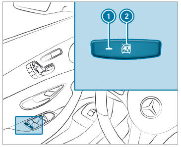
 To activate/deactivate: press button
 . The rear side window can be opened or closed in the following cases:
 is lit: via the switch on the driver's door
Indicator lamp
is lit: via the switch on the driver's door
Indicator lamp  is off: via the switch on the corresponding rear door or driver's door

Copyright © 2026 www.meglc.net